


2024-03-13_07h21m29_ItalyWest_ID000105

oliviergau
User
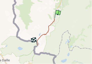

Length
7.9 km

Max alt
3244 m

Uphill gradient
1393 m
Km-Effort
22 km

Min alt
1891 m

Downhill gradient
46 m
Boucle
No
Creation date :
2024-03-13 06:21:29.188
Updated on :
2024-03-13 06:21:30.883

FREE GPS app for hiking
 SityTrail
IGN / Geographical institutes
SityTrail Plus
The world is yours!
About
Trail of 7.9 km to be discovered at Aosta Valley, Unknown, Rhêmes-Notre-Dame. This trail is proposed by oliviergau.
Positioning
Country:
Italy
Region :
Aosta Valley
Department/Province :
Unknown
Municipality :
Rhêmes-Notre-Dame
Location:
Unknown
Start:(Dec)
Start:(UTM)
351773 ; 5044554 (32T) N.
Comments