


ILLE TÊT 66 - PIC PEDROUS - CASESNOVES

jeff66
User
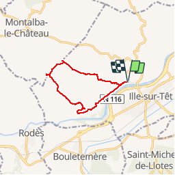

Length
11 km

Max alt
422 m

Uphill gradient
326 m
Km-Effort
15.3 km

Min alt
142 m

Downhill gradient
326 m
Boucle
Yes
Creation date :
2015-05-21 00:00:00.0
Updated on :
2015-05-21 00:00:00.0
2h22
Difficulty : Medium

FREE GPS app for hiking
 SityTrail
IGN / Geographical institutes
SityTrail Plus
The world is yours!
About
Trail Walking of 11 km to be discovered at Occitania, Pyrénées-Orientales, Ille-sur-Têt. This trail is proposed by jeff66.
Positioning
Country:
France
Region :
Occitania
Department/Province :
Pyrénées-Orientales
Municipality :
Ille-sur-Têt
Location:
Unknown
Start:(Dec)
Start:(UTM)
468133 ; 4724922 (31T) N.
Comments