


Bellajoux La Dent 1.593

paul74
User

Length
11.2 km

Max alt
1580 m

Uphill gradient
615 m
Km-Effort
19.4 km

Min alt
973 m

Downhill gradient
638 m
Boucle
Yes
Creation date :
2015-03-20 00:00:00.0
Updated on :
2015-03-20 00:00:00.0
5h13
Difficulty : Unknown

FREE GPS app for hiking
 SityTrail
IGN / Geographical institutes
SityTrail Plus
The world is yours!
About
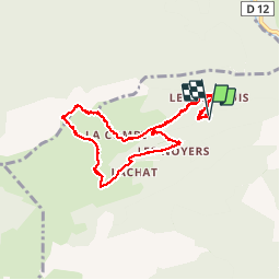
Trail Nordic walking of 11.2 km to be discovered at Auvergne-Rhône-Alpes, Upper Savoy, Glières-Val-de-Borne. This trail is proposed by paul74.
Description
Parking avant La Sambuy Mt 960 aprés la route est verglacée .Col des Chasseurs - La Dent - Restaurant de Bellajoux - retour sur route jeepable. Raquettes utiles- 12 kms
Positioning
Country:
France
Region :
Auvergne-Rhône-Alpes
Department/Province :
Upper Savoy
Municipality :
Glières-Val-de-Borne
Location:
Le Petit-Bornand-les-Glières
Start:(Dec)
Start:(UTM)
296893 ; 5100131 (32T) N.
Comments