


etang noir seignosse

cleu
User
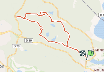

Length
10.7 km

Max alt
61 m

Uphill gradient
163 m
Km-Effort
12.9 km

Min alt
7 m

Downhill gradient
162 m
Boucle
Yes
Creation date :
2024-03-14 08:05:26.488
Updated on :
2024-03-14 18:12:04.71
1h16
Difficulty : Very easy

FREE GPS app for hiking
 SityTrail
IGN / Geographical institutes
SityTrail Plus
The world is yours!
About
Trail Trail of 10.7 km to be discovered at New Aquitaine, Landes, Seignosse. This trail is proposed by cleu.
Positioning
Country:
France
Region :
New Aquitaine
Department/Province :
Landes
Municipality :
Seignosse
Location:
Unknown
Start:(Dec)
Start:(UTM)
630681 ; 4839424 (30T) N.
Comments