


Recuperation

oliviergau
User
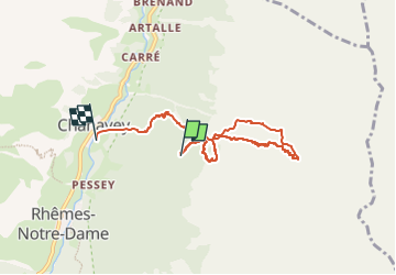

Length
6.5 km

Max alt
2537 m

Uphill gradient
554 m
Km-Effort
15.3 km

Min alt
1687 m

Downhill gradient
966 m
Boucle
No
Creation date :
2024-03-15 08:24:44.671
Updated on :
2024-03-15 11:34:45.381
3h09
Difficulty : Very easy

FREE GPS app for hiking
 SityTrail
IGN / Geographical institutes
SityTrail Plus
The world is yours!
About
Trail Touring skiing of 6.5 km to be discovered at Aosta Valley, Unknown, Rhêmes-Notre-Dame. This trail is proposed by oliviergau.
Positioning
Country:
Italy
Region :
Aosta Valley
Department/Province :
Unknown
Municipality :
Rhêmes-Notre-Dame
Location:
Unknown
Start:(Dec)
Start:(UTM)
354617 ; 5048660 (32T) N.
Comments