


St-Sorlin - cabane équipement

laurentnecca
User
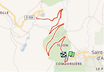

Length
8.8 km

Max alt
1993 m

Uphill gradient
350 m
Km-Effort
13.4 km

Min alt
1639 m

Downhill gradient
349 m
Boucle
Yes
Creation date :
2024-03-15 13:44:54.935
Updated on :
2024-03-15 16:26:23.79
2h41
Difficulty : Easy

FREE GPS app for hiking
 SityTrail
IGN / Geographical institutes
SityTrail Plus
The world is yours!
About
Trail Walking of 8.8 km to be discovered at Auvergne-Rhône-Alpes, Savoy, Saint-Sorlin-d'Arves. This trail is proposed by laurentnecca.
Positioning
Country:
France
Region :
Auvergne-Rhône-Alpes
Department/Province :
Savoy
Municipality :
Saint-Sorlin-d'Arves
Location:
Unknown
Start:(Dec)
Start:(UTM)
281567 ; 5011186 (32T) N.
Comments