


2024-03-17_09h32m06_RS-Comblain-la-Tour-2023-03

Christine Torfs
User
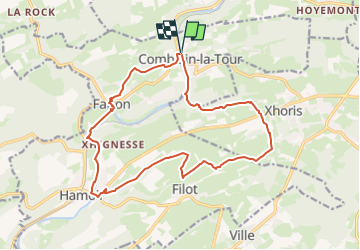

Length
16 km

Max alt
312 m

Uphill gradient
338 m
Km-Effort
21 km

Min alt
104 m

Downhill gradient
339 m
Boucle
Yes
Creation date :
2024-03-17 08:32:06.663
Updated on :
2024-03-17 08:32:07.727

FREE GPS app for hiking
 SityTrail
IGN / Geographical institutes
SityTrail Plus
The world is yours!
About
Trail of 16 km to be discovered at Wallonia, Liège, Hamoir. This trail is proposed by Christine Torfs.
Positioning
Country:
Belgium
Region :
Wallonia
Department/Province :
Liège
Municipality :
Hamoir
Location:
Unknown
Start:(Dec)
Start:(UTM)
682211 ; 5592525 (31U) N.
Comments