


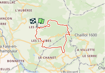
Lac de barbeyroux et canal de Malcros

frizou83
User

Length
14 km

Max alt
1637 m

Uphill gradient
546 m
Km-Effort
21 km

Min alt
1256 m

Downhill gradient
550 m
Boucle
Yes
Creation date :
2024-03-19 10:55:33.956
Updated on :
2024-03-19 12:20:42.522
4h50
Difficulty : Very difficult

FREE GPS app for hiking
 SityTrail
IGN / Geographical institutes
SityTrail Plus
The world is yours!
About
Trail Walking of 14 km to be discovered at Provence-Alpes-Côte d'Azur, Hautes-Alpes, Saint-Bonnet-en-Champsaur. This trail is proposed by frizou83.
Positioning
Country:
France
Region :
Provence-Alpes-Côte d'Azur
Department/Province :
Hautes-Alpes
Municipality :
Saint-Bonnet-en-Champsaur
Location:
Bénévent-et-Charbillac
Start:(Dec)
Start:(UTM)
270688 ; 4953087 (32T) N.
Comments