


24 03 19 divertie

jmbilger
User
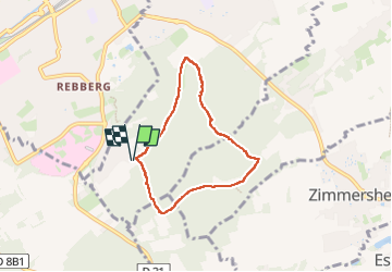

Length
5.7 km

Max alt
354 m

Uphill gradient
136 m
Km-Effort
7.5 km

Min alt
256 m

Downhill gradient
136 m
Boucle
Yes
Creation date :
2024-03-19 13:57:25.0
Updated on :
2024-03-19 15:56:46.049
1h39
Difficulty : Unknown

FREE GPS app for hiking
 SityTrail
IGN / Geographical institutes
SityTrail Plus
The world is yours!
About
Trail Walking of 5.7 km to be discovered at Grand Est, Haut-Rhin, Riedisheim. This trail is proposed by jmbilger.
Positioning
Country:
France
Region :
Grand Est
Department/Province :
Haut-Rhin
Municipality :
Riedisheim
Location:
Unknown
Start:(Dec)
Start:(UTM)
376437 ; 5286940 (32T) N.
Comments