


swwpaunat

michel calvo 2
User
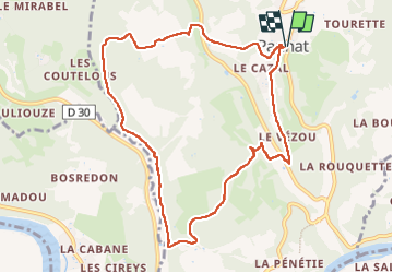

Length
10.5 km

Max alt
171 m

Uphill gradient
283 m
Km-Effort
14.2 km

Min alt
65 m

Downhill gradient
283 m
Boucle
Yes
Creation date :
2024-03-05 13:18:27.126
Updated on :
2024-03-19 16:38:16.417
2h40
Difficulty : Medium

FREE GPS app for hiking
 SityTrail
IGN / Geographical institutes
SityTrail Plus
The world is yours!
About
Trail Walking of 10.5 km to be discovered at New Aquitaine, Dordogne, Paunat. This trail is proposed by michel calvo 2.
Description
belle journée randonnée DIF faculté
Photos

Positioning
Country:
France
Region :
New Aquitaine
Department/Province :
Dordogne
Municipality :
Paunat
Location:
Unknown
Start:(Dec)
Start:(UTM)
331025 ; 4974674 (31T) N.
Comments