


Refuge du col de la Vanoise

ericnavez
User
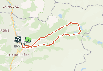

Length
14.7 km

Max alt
2517 m

Uphill gradient
1093 m
Km-Effort
29 km

Min alt
1420 m

Downhill gradient
1098 m
Boucle
Yes
Creation date :
2024-03-22 06:54:54.0
Updated on :
2024-03-22 06:54:55.108

FREE GPS app for hiking
 SityTrail
IGN / Geographical institutes
SityTrail Plus
The world is yours!
About
Trail of 14.7 km to be discovered at Auvergne-Rhône-Alpes, Savoy, Pralognan-la-Vanoise. This trail is proposed by ericnavez.
Positioning
Country:
France
Region :
Auvergne-Rhône-Alpes
Department/Province :
Savoy
Municipality :
Pralognan-la-Vanoise
Location:
Unknown
Start:(Dec)
Start:(UTM)
321733 ; 5027664 (32T) N.
Comments