


eau bourde 14km

domheitz
User
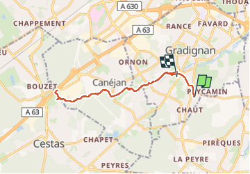

Length
14 km

Max alt
50 m

Uphill gradient
120 m
Km-Effort
15.6 km

Min alt
22 m

Downhill gradient
133 m
Boucle
No
Creation date :
2024-03-25 13:36:16.375
Updated on :
2024-03-25 16:00:01.023
2h20
Difficulty : Very easy

FREE GPS app for hiking
 SityTrail
IGN / Geographical institutes
SityTrail Plus
The world is yours!
About
Trail Trail of 14 km to be discovered at New Aquitaine, Gironde, Gradignan. This trail is proposed by domheitz.
Description
entraînement utah
Positioning
Country:
France
Region :
New Aquitaine
Department/Province :
Gironde
Municipality :
Gradignan
Location:
Unknown
Start:(Dec)
Start:(UTM)
689020 ; 4958782 (30T) N.
Comments