


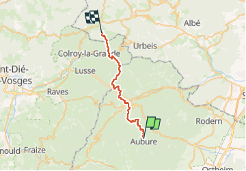
Circuit Alsace Vosges Aubure Bourg Bruche

Tourisme Equestre Alsace
Promouvoir le Tourisme Equestre en Alsace GUIDE+

Length
26 km

Max alt
924 m

Uphill gradient
969 m
Km-Effort
40 km

Min alt
364 m

Downhill gradient
1167 m
Boucle
No
Creation date :
2024-03-27 14:36:04.607
Updated on :
2024-03-27 17:03:03.0
5h15
Difficulty : Medium

FREE GPS app for hiking
 SityTrail
IGN / Geographical institutes
SityTrail Plus
The world is yours!
About
Trail Horseback riding of 26 km to be discovered at Grand Est, Haut-Rhin, Aubure. This trail is proposed by Tourisme Equestre Alsace.
Photos

Positioning
Country:
France
Region :
Grand Est
Department/Province :
Haut-Rhin
Municipality :
Aubure
Location:
Unknown
Start:(Dec)
Start:(UTM)
367904 ; 5340241 (32U) N.
Comments