


Boelensgrab- 28/03/23- Copains alain jeudi

chantalwaltzer
User

Length
47 km

Max alt
1266 m

Uphill gradient
2303 m
Km-Effort
75 km

Min alt
178 m

Downhill gradient
1608 m
Boucle
No
Creation date :
2024-03-28 08:20:26.0
Updated on :
2024-03-28 16:52:37.345
8h30
Difficulty : Unknown

FREE GPS app for hiking
 SityTrail
IGN / Geographical institutes
SityTrail Plus
The world is yours!
About
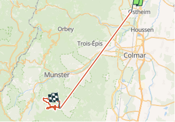
Trail Walking of 47 km to be discovered at Grand Est, Haut-Rhin, Beblenheim. This trail is proposed by chantalwaltzer.
Description
à rzfaire
Positioning
Country:
France
Region :
Grand Est
Department/Province :
Haut-Rhin
Municipality :
Beblenheim
Location:
Unknown
Start:(Dec)
Start:(UTM)
377247 ; 5335275 (32U) N.
Comments