


saint victoire 2

Jean-Claude BOURGUE
User
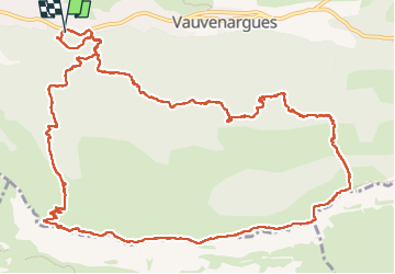

Length
17.1 km

Max alt
998 m

Uphill gradient
772 m
Km-Effort
27 km

Min alt
348 m

Downhill gradient
772 m
Boucle
Yes
Creation date :
2024-03-29 07:57:41.748
Updated on :
2024-03-29 17:08:57.173
5h43
Difficulty : Very difficult

FREE GPS app for hiking
 SityTrail
IGN / Geographical institutes
SityTrail Plus
The world is yours!
About
Trail Walking of 17.1 km to be discovered at Provence-Alpes-Côte d'Azur, Bouches-du-Rhône, Vauvenargues. This trail is proposed by Jean-Claude BOURGUE.
Positioning
Country:
France
Region :
Provence-Alpes-Côte d'Azur
Department/Province :
Bouches-du-Rhône
Municipality :
Vauvenargues
Location:
Unknown
Start:(Dec)
Start:(UTM)
708336 ; 4825541 (31T) N.
Comments