Trail Walking Rebreuviette - REBREUVE SUR CANCHE - Les Champs Graux - Photo

REBREUVE SUR CANCHE - Les Champs Graux

© OpenStreetMap contributors
Length
Length
11.2 km
Max alt
Max alt
157 m
Uphill gradient
Uphill gradient
108 m
Km-Effort
Km-Effort  
12.6 km
Min alt
Min alt
81 m
Downhill gradient
Downhill gradient
108 m
Boucle
Boucle
Yes
Creation date :
2024-03-31 08:06:05.528
Updated on :
2024-03-31 08:14:43.904

(0 Reviews)

Walking
Walking
2h51
Difficulty : Difficult

Scan this QR Code to open this trail in the SityTrail application

FREE GPS app for hiking

Logo SityTrail SityTrail

IGN / Geographical institutes

Download SityTrail from the App Store Download SityTrail from Google Play

Logo SityTrail SityTrail World

The world is yours!

Download SityTrail from the App Store Download SityTrail from Google Play Download SityTrail on Huawei AppGallery

About

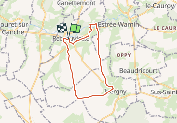
Trail Walking of 11.2 km to be discovered at Hauts-de-France, Pas-de-Calais, Rebreuviette. This trail is proposed by temmichel.

Description

Cette randonnée vous fera découvrir les charmes de la vallée de la Canche
De l'église point de départ vous rejoindrez le GR 124 pour remonter jusqu'à la commune d'Ivergny et de là regagnerez la vallée de la Canche pour suivre le GR 121 et votre point de départ
Bonne randonnée
Jean-Michel

Elevation profile

Photos

Positioning

Country:
France
Region :
Hauts-de-France
Department/Province :
Pas-de-Calais
Municipality :
Rebreuviette
Location:
Unknown
Start:(UTM)
454371 ; 5567991 (31U) N.

Trails nearby

Trail Walking Berlencourt-le-Cauroy - Le sentier du loup (Berlencourt-le-cauroy) - Photo
Walking
tracegps

Walking

Difficult
Berlencourt-le-Cauroy, Hauts-de-France, Pas-de-Calais, France
15.2 km | 17.3 km-effort
3h 45min
Yes
Trail Walking Estrée-Wamin - ESTREE-WAMIN (62) - Les Sertelles - Photo
Walking
temmichel

Walking

Difficult
Estrée-Wamin, Hauts-de-France, Pas-de-Calais, France
11.2 km | 13 km-effort
2h 57min
Yes
Trail Walking Canettemont - CANETTEMONT (62) Le chemin de Saint Pol - Photo
Walking
temmichel

Walking

Medium
Canettemont, Hauts-de-France, Pas-de-Calais, France
8.2 km | 8.9 km-effort
2h 1min
Yes
Trail Walking Frévent - FREVENT  - Photo
Walking
dehemjacques

Walking

Medium
Frévent, Hauts-de-France, Pas-de-Calais, France
27 km | 31 km-effort
6h 42min
Yes
Trail Walking Frévent - Rando Frevent 16 km - Photo
Walking
alainchti62

Walking

Difficult
Frévent, Hauts-de-France, Pas-de-Calais, France
15.9 km | 18.4 km-effort
4h 11min
Yes
Trail Walking Frévent - Frévent (3) 23.5Kms Dén P 319m - Photo
Walking
alain62rando

Walking

Very difficult
Frévent, Hauts-de-France, Pas-de-Calais, France
24 km | 28 km-effort
6h 4min
Yes
Trail Walking Berlencourt-le-Cauroy - Berlencourt/Lucheux 23Kms Dén P 266m - Photo
Walking
alain62rando

Walking

Medium
Berlencourt-le-Cauroy, Hauts-de-France, Pas-de-Calais, France
23 km | 27 km-effort
5h 49min
No
Trail Walking Berlencourt-le-Cauroy - La Cauroy 11.3Kms Dén P 134m - Photo
Walking
alain62rando

Walking

Easy
Berlencourt-le-Cauroy, Hauts-de-France, Pas-de-Calais, France
11.5 km | 13.2 km-effort
2h 54min
Yes


Close
My subscriptions