Trail Walking Frévent - FREVENT  - Photo
© OpenStreetMap contributors
Length
Length
27 km
Max alt
Max alt
149 m
Uphill gradient
Uphill gradient
285 m
Km-Effort
Km-Effort  
31 km
Min alt
Min alt
53 m
Downhill gradient
Downhill gradient
286 m
Boucle
Boucle
Yes
Creation date :
2014-12-10 00:00:00.0
Updated on :
2014-12-10 00:00:00.0

(0 Reviews)

Walking
Walking
6h42
Difficulty : Medium

Scan this QR Code to open this trail in the SityTrail application

FREE GPS app for hiking

Logo SityTrail SityTrail

IGN / Geographical institutes

Download SityTrail from the App Store Download SityTrail from Google Play

Logo SityTrail SityTrail World

The world is yours!

Download SityTrail from the App Store Download SityTrail from Google Play Download SityTrail on Huawei AppGallery

About

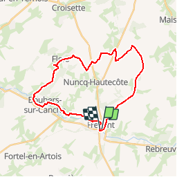
Trail Walking of 27 km to be discovered at Hauts-de-France, Pas-de-Calais, Frévent. This trail is proposed by dehemjacques.

Description

départ par une ancienne voie de chemin de fer jusqu'à petit houvin puis prendre de grp tour du ternois sud jusqu'à enclos annette pour se diriger vers boubers sur canche par le grp tour de la canche-authie

Elevation profile

Positioning

Country:
France
Region :
Hauts-de-France
Department/Province :
Pas-de-Calais
Municipality :
Frévent
Location:
Unknown
Start:(UTM)
449658 ; 5569507 (31U) N.

Trails nearby

Trail Walking Boubers-sur-Canche - 7 km autour de Boubers sur Canche - Photo
Walking
tracegps

Walking

Easy
Boubers-sur-Canche, Hauts-de-France, Pas-de-Calais, France
6.8 km | 7.9 km-effort
1h 40min
Yes
Trail Walking Ligny-sur-Canche - LIGNY SUR CANCHE - Le fond de Boubers - Photo
Walking
temmichel

Walking

Difficult
Ligny-sur-Canche, Hauts-de-France, Pas-de-Calais, France
10.7 km | 12.7 km-effort
2h 52min
Yes
Trail Walking Canettemont - CANETTEMONT (62) Le chemin de Saint Pol - Photo
Walking
temmichel

Walking

Medium
Canettemont, Hauts-de-France, Pas-de-Calais, France
8.2 km | 8.9 km-effort
2h 1min
Yes
Trail Walking Rebreuviette - REBREUVE SUR CANCHE - Les Champs Graux - Photo
Walking
temmichel

Walking

Difficult
Rebreuviette, Hauts-de-France, Pas-de-Calais, France
11.2 km | 12.6 km-effort
2h 51min
Yes
Trail On foot Bonnières - BONNIERES (62) - Les éoliennes - Photo
On foot
temmichel

On foot

Easy
Bonnières, Hauts-de-France, Pas-de-Calais, France
15.2 km | 16.9 km-effort
3h 50min
Yes
Trail Other activity Frévent - Nord - Pas-de-Calais - Ligne 305 - Saint-Roch - Frévent - Photo
Other activity
mich54

Other activity

Very easy
Frévent, Hauts-de-France, Pas-de-Calais, France
11 km | 12.4 km-effort
5min
No
Trail Walking Frévent - Rando Frevent 16 km - Photo
Walking
alainchti62

Walking

Difficult
Frévent, Hauts-de-France, Pas-de-Calais, France
15.9 km | 18.4 km-effort
4h 11min
Yes
Trail Walking Frévent - Frévent (3) 23.5Kms Dén P 319m - Photo
Walking
alain62rando

Walking

Very difficult
Frévent, Hauts-de-France, Pas-de-Calais, France
24 km | 28 km-effort
6h 4min
Yes


Close
My subscriptions