


20240402 Chalet Renard Ventoux

Jeanclaudebic
User
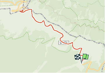

Length
11.6 km

Max alt
1910 m

Uphill gradient
445 m
Km-Effort
17.5 km

Min alt
1455 m

Downhill gradient
446 m
Boucle
Yes
Creation date :
2024-04-02 12:41:15.178
Updated on :
2024-04-02 15:45:40.092
3h04
Difficulty : Difficult

FREE GPS app for hiking
 SityTrail
IGN / Geographical institutes
SityTrail Plus
The world is yours!
About
Trail Walking of 11.6 km to be discovered at Provence-Alpes-Côte d'Azur, Vaucluse, Bédoin. This trail is proposed by Jeanclaudebic.
Positioning
Country:
France
Region :
Provence-Alpes-Côte d'Azur
Department/Province :
Vaucluse
Municipality :
Bédoin
Location:
Unknown
Start:(Dec)
Start:(UTM)
684998 ; 4891310 (31T) N.
Comments