


Schauenberg

jcschubnel
User
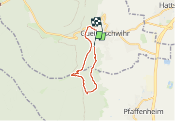

Length
5 km

Max alt
433 m

Uphill gradient
169 m
Km-Effort
7.4 km

Min alt
267 m

Downhill gradient
213 m
Boucle
No
Creation date :
2023-11-01 12:40:49.571
Updated on :
2024-04-02 16:19:51.652
1h58
Difficulty : Medium

FREE GPS app for hiking
 SityTrail
IGN / Geographical institutes
SityTrail Plus
The world is yours!
About
Trail Walking of 5 km to be discovered at Grand Est, Haut-Rhin, Gueberschwihr. This trail is proposed by jcschubnel.
Positioning
Country:
France
Region :
Grand Est
Department/Province :
Haut-Rhin
Municipality :
Gueberschwihr
Location:
Unknown
Start:(Dec)
Start:(UTM)
371111 ; 5317854 (32U) N.
Comments