


soutlz

jcschubnel
User
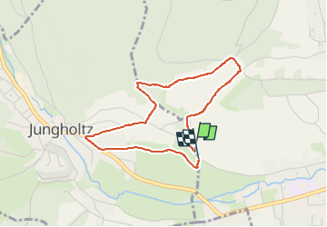

Length
3.4 km

Max alt
361 m

Uphill gradient
66 m
Km-Effort
4.3 km

Min alt
295 m

Downhill gradient
70 m
Boucle
Yes
Creation date :
2024-02-02 12:56:41.906
Updated on :
2024-04-02 16:19:54.62
57m
Difficulty : Easy

FREE GPS app for hiking
 SityTrail
IGN / Geographical institutes
SityTrail Plus
The world is yours!
About
Trail Walking of 3.4 km to be discovered at Grand Est, Haut-Rhin, Jungholtz. This trail is proposed by jcschubnel.
Positioning
Country:
France
Region :
Grand Est
Department/Province :
Haut-Rhin
Municipality :
Jungholtz
Location:
Unknown
Start:(Dec)
Start:(UTM)
366127 ; 5304950 (32T) N.
Comments