


St gilles

jcschubnel
User
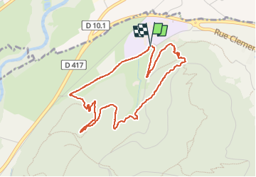

Length
4.5 km

Max alt
377 m

Uphill gradient
161 m
Km-Effort
6.7 km

Min alt
253 m

Downhill gradient
156 m
Boucle
Yes
Creation date :
2024-02-17 13:42:32.239
Updated on :
2024-04-02 16:19:57.551
1h19
Difficulty : Medium

FREE GPS app for hiking
 SityTrail
IGN / Geographical institutes
SityTrail Plus
The world is yours!
About
Trail Walking of 4.5 km to be discovered at Grand Est, Haut-Rhin, Wintzenheim. This trail is proposed by jcschubnel.
Positioning
Country:
France
Region :
Grand Est
Department/Province :
Haut-Rhin
Municipality :
Wintzenheim
Location:
Unknown
Start:(Dec)
Start:(UTM)
370765 ; 5326163 (32U) N.
Comments