


Sentier des moines

jcschubnel
User
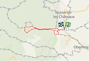

Length
5.6 km

Max alt
560 m

Uphill gradient
215 m
Km-Effort
8.4 km

Min alt
352 m

Downhill gradient
215 m
Boucle
Yes
Creation date :
2024-02-18 13:38:30.269
Updated on :
2024-04-02 16:19:58.913
2h14
Difficulty : Medium

FREE GPS app for hiking
 SityTrail
IGN / Geographical institutes
SityTrail Plus
The world is yours!
About
Trail Walking of 5.6 km to be discovered at Grand Est, Haut-Rhin, Eguisheim. This trail is proposed by jcschubnel.
Positioning
Country:
France
Region :
Grand Est
Department/Province :
Haut-Rhin
Municipality :
Eguisheim
Location:
Unknown
Start:(Dec)
Start:(UTM)
371854 ; 5320665 (32U) N.
Comments