


Colmar r

jcschubnel
User
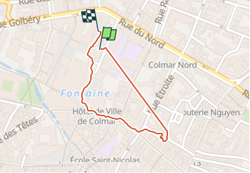

Length
713 m

Max alt
196 m

Uphill gradient
3 m
Km-Effort
749 m

Min alt
192 m

Downhill gradient
2 m
Boucle
Yes
Creation date :
2024-04-04 13:56:06.157
Updated on :
2024-04-04 21:38:10.324
9m
Difficulty : Easy

FREE GPS app for hiking
 SityTrail
IGN / Geographical institutes
SityTrail Plus
The world is yours!
About
Trail Walking of 713 m to be discovered at Grand Est, Haut-Rhin, Colmar. This trail is proposed by jcschubnel.
Positioning
Country:
France
Region :
Grand Est
Department/Province :
Haut-Rhin
Municipality :
Colmar
Location:
Unknown
Start:(Dec)
Start:(UTM)
377726 ; 5326542 (32U) N.
Comments