


Chez chacha

viaul
User GUIDE

Length
8.2 km

Max alt
977 m

Uphill gradient
235 m
Km-Effort
11.3 km

Min alt
818 m

Downhill gradient
223 m
Boucle
No
Creation date :
2024-04-06 09:02:16.0
Updated on :
2024-04-06 11:30:59.83

FREE GPS app for hiking
 SityTrail
IGN / Geographical institutes
SityTrail Plus
The world is yours!
About
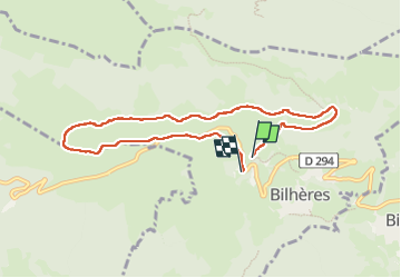
Trail of 8.2 km to be discovered at New Aquitaine, Pyrénées-Atlantiques, Bilhères. This trail is proposed by viaul.
Positioning
Country:
France
Region :
New Aquitaine
Department/Province :
Pyrénées-Atlantiques
Municipality :
Bilhères
Location:
Unknown
Start:(Dec)
Start:(UTM)
707135 ; 4770959 (30T) N.
Comments