Trail Walking Saint-Pierre-de-Manneville - st pierre de mainneville - Photo
© OpenStreetMap contributors
Length
Length
7.6 km
Max alt
Max alt
71 m
Uphill gradient
Uphill gradient
92 m
Km-Effort
Km-Effort  
8.9 km
Min alt
Min alt
-2 m
Downhill gradient
Downhill gradient
92 m
Boucle
Boucle
Yes
Creation date :
2024-04-07 08:00:49.465
Updated on :
2024-04-07 09:26:45.061

(0 Reviews)

Walking
Walking
1h25
Difficulty : Medium

Scan this QR Code to open this trail in the SityTrail application

FREE GPS app for hiking

Logo SityTrail SityTrail

IGN / Geographical institutes

Download SityTrail from the App Store Download SityTrail from Google Play

Logo SityTrail SityTrail World

The world is yours!

Download SityTrail from the App Store Download SityTrail from Google Play Download SityTrail on Huawei AppGallery

About

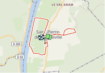
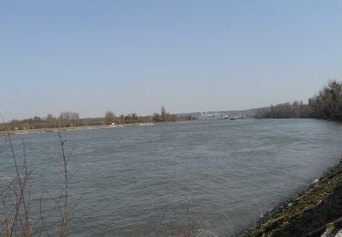
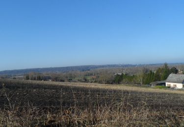
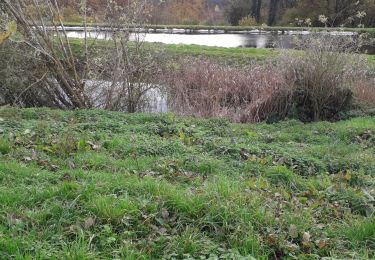
Trail Walking of 7.6 km to be discovered at Normandy, Seine-Maritime, Saint-Pierre-de-Manneville. This trail is proposed by Philippe Auguste.

Description

moyen

Elevation profile

Photos

Positioning

Country:
France
Region :
Normandy
Department/Province :
Seine-Maritime
Municipality :
Saint-Pierre-de-Manneville
Location:
Unknown
Start:(UTM)
349776 ; 5472789 (31U) N.

Trails nearby

Trail Walking Hautot-sur-Seine - Hautot-sur-seine  11km  - Photo
Walking
MichelRando7656

Walking

Medium
(2)
Hautot-sur-Seine, Normandy, Seine-Maritime, France
11 km | 12.2 km-effort
2h 37min
Yes
Trail Walking Saint-Ouen-de-Thouberville - Saint-Ouen de Thouberville- Le Mesnil et la Pierre TTournante  - Photo
Walking
MichelRando7656

Walking

Medium
(1)
Saint-Ouen-de-Thouberville, Normandy, Eure, France
12.5 km | 15.3 km-effort
3h 35min
Yes
Trail On foot Saint-Pierre-de-Manneville - Du coté du Manoir de Villers - Photo
On foot
JMCMoreau

On foot

Easy
(1)
Saint-Pierre-de-Manneville, Normandy, Seine-Maritime, France
11 km | 12.5 km-effort
2h 45min
Yes
Trail Walking Canteleu - canteleu parc animalier - Photo
Walking
nicole.reine@wanadoo.fr

Walking

Very easy
(1)
Canteleu, Normandy, Seine-Maritime, France
6.5 km | 7.4 km-effort
1h 37min
Yes
Trail Walking La Bouille - La Bouille- Cote Albert Lambert-Robert le Diable - Photo
Walking
MichelRando7656

Walking

Difficult
La Bouille, Normandy, Seine-Maritime, France
14.9 km | 18.8 km-effort
4h 23min
Yes
Trail Walking Sahurs - 20231216-sahurs - Photo
Walking
doudet

Walking

Medium
Sahurs, Normandy, Seine-Maritime, France
12.8 km | 14.2 km-effort
3h 18min
Yes
Trail Walking La Bouille - 20220322-La Bouille  - Photo
Walking
doudet

Walking

Medium
La Bouille, Normandy, Seine-Maritime, France
12.8 km | 15.8 km-effort
3h 36min
Yes
Trail Walking Quevillon - 20211218-Quevillon  - Photo
Walking
doudet

Walking

Medium
Quevillon, Normandy, Seine-Maritime, France
12.7 km | 15.3 km-effort
3h 34min
Yes
Trail Walking Saint-Ouen-de-Thouberville - Saint-Ouen de Thouberville.  Vers la pierre Tourmante et le Mesnil version 12-11-21 - Photo
Walking
MichelRando7656

Walking

Difficult
Saint-Ouen-de-Thouberville, Normandy, Eure, France
12.8 km | 15.6 km-effort
3h 55min
Yes


Close
My subscriptions