


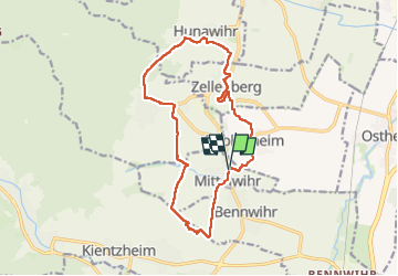
Mittelwihr - Beblenheim - Zellenberg - Hunawihr - Riquewihr - Nécropole de Sigolsheim

VacheKiri67
User

Length
14.5 km

Max alt
382 m

Uphill gradient
363 m
Km-Effort
19.3 km

Min alt
209 m

Downhill gradient
362 m
Boucle
Yes
Creation date :
2024-04-07 07:51:46.646
Updated on :
2024-04-09 16:34:17.326
4h08
Difficulty : Medium

FREE GPS app for hiking
 SityTrail
IGN / Geographical institutes
SityTrail Plus
The world is yours!
About
Trail Walking of 14.5 km to be discovered at Grand Est, Haut-Rhin, Mittelwihr. This trail is proposed by VacheKiri67.
Description
Faite le 07/04/2024.
Au départ de Mittelwihr.
Un des nos parcours préféré à travers les grands crus du vignoble.
Photos


22 photos in total. Please click on a photo to see them all in the gallery.
Positioning
Country:
France
Region :
Grand Est
Department/Province :
Haut-Rhin
Municipality :
Mittelwihr
Location:
Unknown
Start:(Dec)
Start:(UTM)
375137 ; 5334622 (32U) N.
Comments