


Les Monts depuis le centre ville

Iahns
User
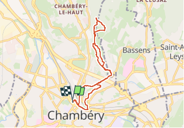

Length
7.8 km

Max alt
499 m

Uphill gradient
250 m
Km-Effort
11.1 km

Min alt
273 m

Downhill gradient
251 m
Boucle
Yes
Creation date :
2024-04-07 12:17:35.132
Updated on :
2024-04-07 14:22:08.514
2h04
Difficulty : Medium

FREE GPS app for hiking
 SityTrail
IGN / Geographical institutes
SityTrail Plus
The world is yours!
About
Trail Walking of 7.8 km to be discovered at Auvergne-Rhône-Alpes, Savoy, Chambéry. This trail is proposed by Iahns.
Positioning
Country:
France
Region :
Auvergne-Rhône-Alpes
Department/Province :
Savoy
Municipality :
Chambéry
Location:
Unknown
Start:(Dec)
Start:(UTM)
727791 ; 5050358 (31T) N.
Comments