Trail Walking Choloy-Ménillot - Cholloy-Ménillot 14 150m +335m - Photo

Cholloy-Ménillot 14 150m +335m

© OpenStreetMap contributors
Length
Length
14.2 km
Max alt
Max alt
395 m
Uphill gradient
Uphill gradient
336 m
Km-Effort
Km-Effort  
18.6 km
Min alt
Min alt
241 m
Downhill gradient
Downhill gradient
336 m
Boucle
Boucle
Yes
Creation date :
2024-04-09 06:51:25.653
Updated on :
2024-04-09 16:51:41.11

(0 Reviews)

Walking
Walking
3h30
Difficulty : Difficult

Scan this QR Code to open this trail in the SityTrail application

FREE GPS app for hiking

Logo SityTrail SityTrail

IGN / Geographical institutes

Download SityTrail from the App Store Download SityTrail from Google Play

Logo SityTrail SityTrail World

The world is yours!

Download SityTrail from the App Store Download SityTrail from Google Play Download SityTrail on Huawei AppGallery

About

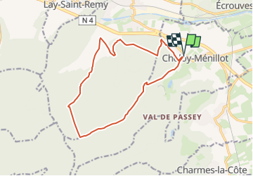
Trail Walking of 14.2 km to be discovered at Grand Est, Meurthe-et-Moselle, Choloy-Ménillot. This trail is proposed by DanielROLLET.

Description

2024 04 09 - 8h50 à 12h20 - avec Marie
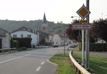
Départ/retour parking mairie
Petite pluie au départ puis temps couvert avec légère brise.
Du muguet (en boutons) sur tout le plateau

Elevation profile

Positioning

Country:
France
Region :
Grand Est
Department/Province :
Meurthe-et-Moselle
Municipality :
Choloy-Ménillot
Location:
Unknown
Start:(UTM)
707243 ; 5393795 (31U) N.

Trails nearby

Trail On foot Bruley - Circuit de la Petite Linotte - Photo
On foot
PRO

On foot

Easy
Bruley, Grand Est, Meurthe-et-Moselle, France
9.2 km | 12 km-effort
2h 43min
No
Trail Mountain bike Écrouves - 1 ère rando VTT - Photo
Mountain bike
ericsnoopy

Mountain bike

Very easy
(1)
Écrouves, Grand Est, Meurthe-et-Moselle, France
7.5 km | 9.5 km-effort
Unknown
Yes
Trail On foot Foug - Circuit de Grammont - Photo
On foot
PRO

On foot

Easy
Foug, Grand Est, Meurthe-et-Moselle, France
15.6 km | 19.3 km-effort
4h 23min
No
Trail On foot Choloy-Ménillot - Boucle des Sources - Photo
On foot
PRO

On foot

Easy
Choloy-Ménillot, Grand Est, Meurthe-et-Moselle, France
10.4 km | 11.9 km-effort
2h 42min
No
Trail On foot Lay-Saint-Remy - Circuit des Tunnels - Photo
On foot
PRO

On foot

Easy
Lay-Saint-Remy, Grand Est, Meurthe-et-Moselle, France
11.1 km | 14.2 km-effort
3h 14min
No
Trail On foot Laneuveville-derrière-Foug - Circuit du Point du Jour - Photo
On foot
PRO

On foot

Easy
Laneuveville-derrière-Foug, Grand Est, Meurthe-et-Moselle, France
6.8 km | 8 km-effort
1h 49min
No
Trail On foot Pagney-derrière-Barine - Circuit du Val des Nonnes - Photo
On foot
PRO

On foot

Easy
Pagney-derrière-Barine, Grand Est, Meurthe-et-Moselle, France
14.9 km | 19 km-effort
4h 19min
Yes
Trail On foot Écrouves - Sentier Toul-Thiaucourt - Photo
On foot
PRO

On foot

Medium
Écrouves, Grand Est, Meurthe-et-Moselle, France
22 km | 24 km-effort
5h 28min
No
Trail On foot Écrouves - Chemin des Chanottes - Photo
On foot
PRO

On foot

Easy
Écrouves, Grand Est, Meurthe-et-Moselle, France
5.6 km | 6.4 km-effort
1h 27min
No


Close
My subscriptions