


sentier minier

mikaou.t
User
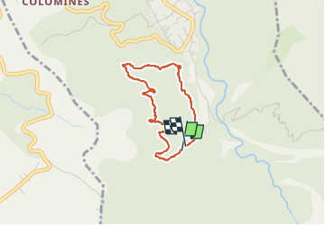

Length
3.2 km

Max alt
755 m

Uphill gradient
130 m
Km-Effort
5 km

Min alt
619 m

Downhill gradient
141 m
Boucle
Yes
Creation date :
2024-04-11 12:54:08.947
Updated on :
2024-04-11 15:37:28.423
2h42
Difficulty : Easy

FREE GPS app for hiking
 SityTrail
IGN / Geographical institutes
SityTrail Plus
The world is yours!
About
Trail Walking of 3.2 km to be discovered at Occitania, Pyrénées-Orientales, Taurinya. This trail is proposed by mikaou.t.
Positioning
Country:
France
Region :
Occitania
Department/Province :
Pyrénées-Orientales
Municipality :
Taurinya
Location:
Unknown
Start:(Dec)
Start:(UTM)
453014 ; 4713175 (31T) N.
Comments