


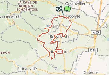
St-Hippolyte - Rorschwihr - Grasberg - Bergheim - Reichenberg - Rodern

VacheKiri67
User

Length
17.3 km

Max alt
381 m

Uphill gradient
353 m
Km-Effort
22 km

Min alt
202 m

Downhill gradient
353 m
Boucle
Yes
Creation date :
2024-04-14 07:49:02.745
Updated on :
2024-04-15 15:38:10.55
4h28
Difficulty : Medium

FREE GPS app for hiking
 SityTrail
IGN / Geographical institutes
SityTrail Plus
The world is yours!
About
Trail Walking of 17.3 km to be discovered at Grand Est, Haut-Rhin, Saint-Hippolyte. This trail is proposed by VacheKiri67.
Description
Faite le 14/04/2024. Le départ peut aussi se faire de Bergheim.
Photos


34 photos in total. Please click on a photo to see them all in the gallery.
Positioning
Country:
France
Region :
Grand Est
Department/Province :
Haut-Rhin
Municipality :
Saint-Hippolyte
Location:
Unknown
Start:(Dec)
Start:(UTM)
378682 ; 5343485 (32U) N.
Comments