


rodes crêtes ripodere 306m 8km2

Erius
User
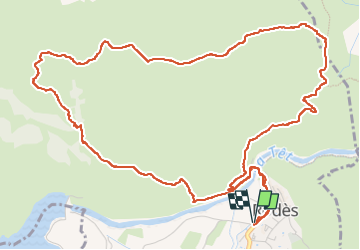

Length
8.2 km

Max alt
467 m

Uphill gradient
306 m
Km-Effort
12.3 km

Min alt
195 m

Downhill gradient
306 m
Boucle
Yes
Creation date :
2024-04-16 07:57:05.557
Updated on :
2024-04-16 12:50:14.993
3h14
Difficulty : Medium

FREE GPS app for hiking
 SityTrail
IGN / Geographical institutes
SityTrail Plus
The world is yours!
About
Trail Walking of 8.2 km to be discovered at Occitania, Pyrénées-Orientales, Rodès. This trail is proposed by Erius.
Positioning
Country:
France
Region :
Occitania
Department/Province :
Pyrénées-Orientales
Municipality :
Rodès
Location:
Unknown
Start:(Dec)
Start:(UTM)
463968 ; 4722776 (31T) N.
Comments