


2024 04 Guebwiller Nez de Soultz

staubalex
User
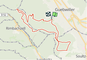

Length
10.8 km

Max alt
629 m

Uphill gradient
471 m
Km-Effort
17.1 km

Min alt
337 m

Downhill gradient
464 m
Boucle
Yes
Creation date :
2024-04-17 12:05:50.692
Updated on :
2024-04-17 12:06:39.763
3h52
Difficulty : Difficult

FREE GPS app for hiking
 SityTrail
IGN / Geographical institutes
SityTrail Plus
The world is yours!
About
Trail Walking of 10.8 km to be discovered at Grand Est, Haut-Rhin, Guebwiller. This trail is proposed by staubalex.
Positioning
Country:
France
Region :
Grand Est
Department/Province :
Haut-Rhin
Municipality :
Guebwiller
Location:
Unknown
Start:(Dec)
Start:(UTM)
365633 ; 5307253 (32T) N.
Comments