Trail Walking Montberon - 31_Montberon_projet_rs - Photo

31_Montberon_projet_rs

 jab31
jab31

User

© OpenStreetMap contributors
Length
Length
7.8 km
Max alt
Max alt
185 m
Uphill gradient
Uphill gradient
100 m
Km-Effort
Km-Effort  
9.1 km
Min alt
Min alt
144 m
Downhill gradient
Downhill gradient
102 m
Boucle
Boucle
Yes
Creation date :
2024-04-17 13:32:07.925
Updated on :
2024-04-17 13:38:54.845

(0 Reviews)

Walking
Walking
2h16
Difficulty : Easy

Scan this QR Code to open this trail in the SityTrail application

FREE GPS app for hiking

Logo SityTrail SityTrail

IGN / Geographical institutes

Download SityTrail from the App Store Download SityTrail from Google Play

Logo SityTrail SityTrail World

The world is yours!

Download SityTrail from the App Store Download SityTrail from Google Play Download SityTrail on Huawei AppGallery

About

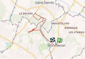
Trail Walking of 7.8 km to be discovered at Occitania, Haute-Garonne, Montberon. This trail is proposed by jab31.

Description

boucle autour du bois de montberon

Elevation profile

Positioning

Country:
France
Region :
Occitania
Department/Province :
Haute-Garonne
Municipality :
Montberon
Location:
Unknown
Start:(UTM)
377539 ; 4841446 (31T) N.

Trails nearby

Trail Walking Villariès - De Villariès à Vacquiers - Photo
Walking
tracegps

Walking

Medium
(1)
Villariès, Occitania, Haute-Garonne, France
11.5 km | 13.4 km-effort
3h 0min
Yes
Trail Walking Castelginest - Le long de l'Hers à Castelginest - Photo
Walking
tracegps

Walking

Easy
(1)
Castelginest, Occitania, Haute-Garonne, France
6.8 km | 7.2 km-effort
1h 30min
Yes
Trail Mountain bike Gargas - VTT dans le Frontonnais entre Gargas, Vacquiers et Montjoire - Photo
Mountain bike
tracegps

Mountain bike

Medium
(1)
Gargas, Occitania, Haute-Garonne, France
29 km | 35 km-effort
2h 30min
Yes
Trail Walking Pechbonnieu - 7 km dans 1 km - Photo
Walking
zazibelle

Walking

Medium
Pechbonnieu, Occitania, Haute-Garonne, France
7.1 km | 8.7 km-effort
1h 34min
Yes
Trail Running Villariès - De Villariès à Vacquiers - Photo
Running
tracegps

Running

Medium
Villariès, Occitania, Haute-Garonne, France
11.5 km | 13.4 km-effort
1h 15min
Yes
Trail Running Labastide-Saint-Sernin - Le Bois de Lespasié au dessus de Labastide Saint Sernin - Photo
Running
tracegps

Running

Medium
Labastide-Saint-Sernin, Occitania, Haute-Garonne, France
6.5 km | 7.5 km-effort
40min
Yes
Trail Walking Labastide-Saint-Sernin - Le Bois de Lespasié au dessus de Labastide Saint Sernin - Photo
Walking
tracegps

Walking

Medium
(1)
Labastide-Saint-Sernin, Occitania, Haute-Garonne, France
6.5 km | 7.5 km-effort
1h 49min
Yes
Trail Running Castelginest - Le long de l'Hers à Castelginest - Photo
Running
tracegps

Running

Easy
Castelginest, Occitania, Haute-Garonne, France
6.8 km | 7.2 km-effort
40min
Yes
Trail Running Launaguet - Course à pied gps à Launaguet - Chemin du Poutou - Photo
Running
tracegps

Running

Difficult
Launaguet, Occitania, Haute-Garonne, France
18.7 km | 22 km-effort
1h 30min
Yes


Close
My subscriptions