Trail Cycle Villefontaine - Châteaux et talwegs - Photo
© OpenStreetMap contributors
Length
Length
62 km
Max alt
Max alt
490 m
Uphill gradient
Uphill gradient
871 m
Km-Effort
Km-Effort  
74 km
Min alt
Min alt
218 m
Downhill gradient
Downhill gradient
870 m
Boucle
Boucle
Yes
Creation date :
2019-03-13 14:07:27.849
Updated on :
2019-03-13 14:07:27.882

(0 Reviews)

Cycle
Cycle
4h13
Difficulty : Medium

Scan this QR Code to open this trail in the SityTrail application

FREE GPS app for hiking

Logo SityTrail SityTrail

IGN / Geographical institutes

Download SityTrail from the App Store Download SityTrail from Google Play

Logo SityTrail SityTrail World

The world is yours!

Download SityTrail from the App Store Download SityTrail from Google Play Download SityTrail on Huawei AppGallery

About

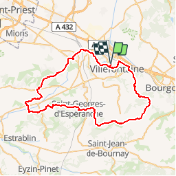
Trail Cycle of 62 km to be discovered at Auvergne-Rhône-Alpes, Isère, Villefontaine. This trail is proposed by lapldc97418.

Description

La route des châteaux on va trouver celui du Vellein de Fallavier de Maille de Septème de Monbaly il y a du roulant mais aussi de belles montées.Après St Quentin-Fallavier on prend la D76 jusqu'à Heyrieux, très fréquentée "danger". Après Heyrieux et juste avant d'arriver à St-Just-Chaleyssin les montées sont raides  et puis après encore une belle montée en perspective avant la descente sur Septème. Danger de Glandut à la D75 la descente est presque à la verticale. Après Oytier-st-Oblas  au niveau  Granges des dames on prend à gauche une route qui grimpe en forêt pour arriver  à proximité de la Madonne puis le circuit continue par la droite

Elevation profile

Positioning

Country:
France
Region :
Auvergne-Rhône-Alpes
Department/Province :
Isère
Municipality :
Villefontaine
Location:
Unknown
Start:(UTM)
667284 ; 5054055 (31T) N.

Trails nearby

Trail Walking Bonnefamille - Bonne  Famille - Photo
Walking
GILGilbert

Walking

Very easy
(1)
Bonnefamille, Auvergne-Rhône-Alpes, Isère, France
8.4 km | 10.6 km-effort
2h 23min
Yes
Trail Mountain bike Vaulx-Milieu - Les étangs et le golf - Photo
Mountain bike
epa jjomain

Mountain bike

Vaulx-Milieu, Auvergne-Rhône-Alpes, Isère, France
13.1 km | 16.1 km-effort
1h 18min
No
Trail Walking Vaulx-Milieu - vaulx - Photo
Walking
mumdol

Walking

Very easy
Vaulx-Milieu, Auvergne-Rhône-Alpes, Isère, France
7.1 km | 9 km-effort
2h 2min
Yes
Trail Walking Villefontaine - ulk pillery - Photo
Walking
ACEL

Walking

Medium
Villefontaine, Auvergne-Rhône-Alpes, Isère, France
381 km | 442 km-effort
181h 2min
No
Trail Walking Villefontaine - LAETITIA  - Photo
Walking
Marc Dauvergne

Walking

Very easy
Villefontaine, Auvergne-Rhône-Alpes, Isère, France
3.2 km | 3.9 km-effort
1h 3min
Yes
Trail Walking Saint-Quentin-Fallavier - Saint Quantin Falavier   - Photo
Walking
GILGilbert

Walking

Medium
Saint-Quentin-Fallavier, Auvergne-Rhône-Alpes, Isère, France
10.8 km | 13.4 km-effort
3h 8min
Yes
Trail Bicycle tourism Vaulx-Milieu - Vaulx-Milieu - Hauterives - Photo
Bicycle tourism
karawatsj

Bicycle tourism

Difficult
Vaulx-Milieu, Auvergne-Rhône-Alpes, Isère, France
61 km | 75 km-effort
3h 19min
No
Trail Cycle Villefontaine - Villages et Châteaux - Photo
Cycle
lapldc97418

Cycle

Medium
Villefontaine, Auvergne-Rhône-Alpes, Isère, France
49 km | 57 km-effort
3h 18min
Yes
Trail Mountain bike Diémoz - De Saint Georges d'Espéranche à Artas - Photo
Mountain bike
tracegps

Mountain bike

Medium
Diémoz, Auvergne-Rhône-Alpes, Isère, France
33 km | 41 km-effort
2h 30min
Yes


Close
My subscriptions