


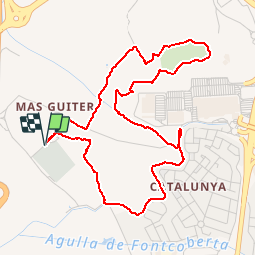
PERPIGNAN 66 - Serrat d'en vaquer

jeff66
User

Length
5.8 km

Max alt
90 m

Uphill gradient
72 m
Km-Effort
6.7 km

Min alt
48 m

Downhill gradient
72 m
Boucle
Yes
Creation date :
2015-05-21 00:00:00.0
Updated on :
2015-05-21 00:00:00.0
56m
Difficulty : Very easy

FREE GPS app for hiking
 SityTrail
IGN / Geographical institutes
SityTrail Plus
The world is yours!
About
Trail Walking of 5.8 km to be discovered at Occitania, Pyrénées-Orientales, Perpignan. This trail is proposed by jeff66.
Description
PERPIGNAN 66 - Cimetière Sud - Serrat d'en vaquer - Las Canals
Positioning
Country:
France
Region :
Occitania
Department/Province :
Pyrénées-Orientales
Municipality :
Perpignan
Location:
Unknown
Start:(Dec)
Start:(UTM)
489060 ; 4723785 (31T) N.
Comments