


Turckheim - zimmerbach par vigne et forêt

OxygenLT
User
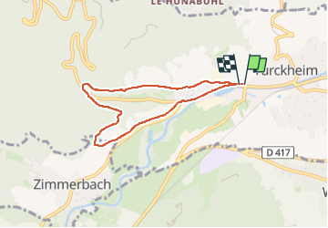

Length
6.1 km

Max alt
350 m

Uphill gradient
128 m
Km-Effort
7.8 km

Min alt
241 m

Downhill gradient
125 m
Boucle
Yes
Creation date :
2024-04-22 13:38:06.633
Updated on :
2024-04-22 14:56:00.854
1h17
Difficulty : Easy

FREE GPS app for hiking
 SityTrail
IGN / Geographical institutes
SityTrail Plus
The world is yours!
About
Trail Walking of 6.1 km to be discovered at Grand Est, Haut-Rhin, Turckheim. This trail is proposed by OxygenLT.
Positioning
Country:
France
Region :
Grand Est
Department/Province :
Haut-Rhin
Municipality :
Turckheim
Location:
Unknown
Start:(Dec)
Start:(UTM)
371181 ; 5327313 (32U) N.
Comments