


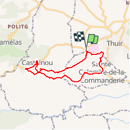
THUIR 66 - Castelnou - Ste Colombe de la C.

jeff66
User

Length
14.8 km

Max alt
440 m

Uphill gradient
477 m
Km-Effort
21 km

Min alt
122 m

Downhill gradient
486 m
Boucle
Yes
Creation date :
2015-05-21 00:00:00.0
Updated on :
2015-05-21 00:00:00.0
2h56
Difficulty : Medium

FREE GPS app for hiking
 SityTrail
IGN / Geographical institutes
SityTrail Plus
The world is yours!
About
Trail Walking of 14.8 km to be discovered at Occitania, Pyrénées-Orientales, Sainte-Colombe-de-la-Commanderie. This trail is proposed by jeff66.
Description
Thuir hôpital- Roc Majorque- Castelnou- Col de la Creu- Sainte Colombe de la C.-
Positioning
Country:
France
Region :
Occitania
Department/Province :
Pyrénées-Orientales
Municipality :
Sainte-Colombe-de-la-Commanderie
Location:
Unknown
Start:(Dec)
Start:(UTM)
478380 ; 4719244 (31T) N.
Comments