


baigura_tourcretes_osses_st_martin_d_arrossaarl-5550436-1713967244-940

topolino
User
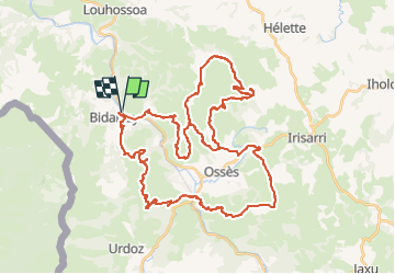

Length
54 km

Max alt
885 m

Uphill gradient
2885 m
Km-Effort
93 km

Min alt
75 m

Downhill gradient
2884 m
Boucle
Yes
Creation date :
2024-04-24 14:01:12.744
Updated on :
2024-04-24 14:01:44.67
6h25
Difficulty : Very difficult

FREE GPS app for hiking
 SityTrail
IGN / Geographical institutes
SityTrail Plus
The world is yours!
About
Trail Mountain bike of 54 km to be discovered at New Aquitaine, Pyrénées-Atlantiques, Bidarray. This trail is proposed by topolino.
Positioning
Country:
France
Region :
New Aquitaine
Department/Province :
Pyrénées-Atlantiques
Municipality :
Bidarray
Location:
Unknown
Start:(Dec)
Start:(UTM)
634254 ; 4792035 (30T) N.
Comments