


gap_vizille-oct2023

aeldin
User
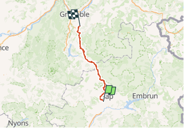

Length
117 km

Max alt
1709 m

Uphill gradient
3482 m
Km-Effort
164 km

Min alt
278 m

Downhill gradient
3943 m
Boucle
No
Creation date :
2024-04-26 10:18:18.381
Updated on :
2024-09-19 17:46:37.264
21h38
Difficulty : Very difficult

FREE GPS app for hiking
 SityTrail
IGN / Geographical institutes
SityTrail Plus
The world is yours!
About
Trail Horseback riding of 117 km to be discovered at Provence-Alpes-Côte d'Azur, Hautes-Alpes, Gap. This trail is proposed by aeldin.

Positioning
Country:
France
Region :
Provence-Alpes-Côte d'Azur
Department/Province :
Hautes-Alpes
Municipality :
Gap
Location:
Gap
Start:(Dec)
Start:(UTM)
265022 ; 4933738 (32T) N.
Comments