


G4 Momas

LouisROGER
User GUIDE
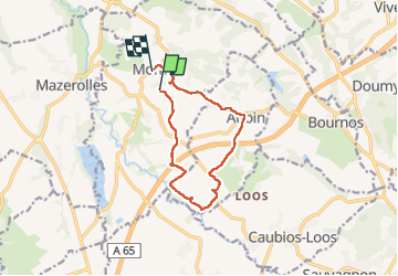

Length
11 km

Max alt
219 m

Uphill gradient
167 m
Km-Effort
13.3 km

Min alt
155 m

Downhill gradient
168 m
Boucle
No
Creation date :
2024-04-26 08:25:13.07
Updated on :
2024-04-26 13:47:50.344
5h21
Difficulty : Difficult

FREE GPS app for hiking
 SityTrail
IGN / Geographical institutes
SityTrail Plus
The world is yours!
About
Trail Walking of 11 km to be discovered at New Aquitaine, Pyrénées-Atlantiques, Momas. This trail is proposed by LouisROGER.
Photos

Positioning
Country:
France
Region :
New Aquitaine
Department/Province :
Pyrénées-Atlantiques
Municipality :
Momas
Location:
Unknown
Start:(Dec)
Start:(UTM)
707003 ; 4813532 (30T) N.
Comments