


Liebsdorf

Alain28/01
User
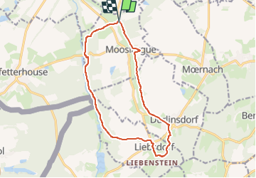

Length
14 km

Max alt
543 m

Uphill gradient
259 m
Km-Effort
17.5 km

Min alt
401 m

Downhill gradient
255 m
Boucle
Yes
Creation date :
2024-04-27 10:51:46.463
Updated on :
2024-04-27 10:52:38.765
3h58
Difficulty : Easy

FREE GPS app for hiking
 SityTrail
IGN / Geographical institutes
SityTrail Plus
The world is yours!
About
Trail On foot of 14 km to be discovered at Grand Est, Haut-Rhin, Mooslargue. This trail is proposed by Alain28/01.
Positioning
Country:
France
Region :
Grand Est
Department/Province :
Haut-Rhin
Municipality :
Mooslargue
Location:
Unknown
Start:(Dec)
Start:(UTM)
365588 ; 5264395 (32T) N.
Comments