


Aubure Aldespach

vaillantjm
User
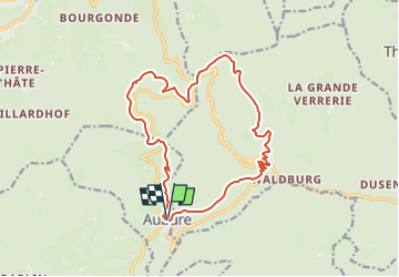

Length
15.3 km

Max alt
924 m

Uphill gradient
701 m
Km-Effort
25 km

Min alt
455 m

Downhill gradient
700 m
Boucle
Yes
Creation date :
2024-05-03 08:26:04.265
Updated on :
2024-08-31 16:45:26.908
5h30
Difficulty : Difficult

FREE GPS app for hiking
 SityTrail
IGN / Geographical institutes
SityTrail Plus
The world is yours!
About
Trail Walking of 15.3 km to be discovered at Grand Est, Haut-Rhin, Aubure. This trail is proposed by vaillantjm.
Description
Cette randonnée a pour particularité de commencer par une longue descente jusqu'à la Maison Forestière Iberg. Ensuite, ça grimpe!
Positioning
Country:
France
Region :
Grand Est
Department/Province :
Haut-Rhin
Municipality :
Aubure
Location:
Unknown
Start:(Dec)
Start:(UTM)
367906 ; 5339765 (32U) N.
Comments