


Turckheim - chalet club vosgien

OxygenLT
User
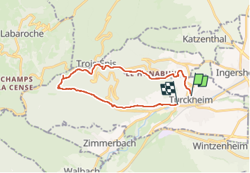

Length
12.6 km

Max alt
711 m

Uphill gradient
497 m
Km-Effort
19.2 km

Min alt
239 m

Downhill gradient
497 m
Boucle
No
Creation date :
2024-05-03 08:22:59.927
Updated on :
2024-05-03 11:47:01.908
3h03
Difficulty : Medium

FREE GPS app for hiking
 SityTrail
IGN / Geographical institutes
SityTrail Plus
The world is yours!
About
Trail Walking of 12.6 km to be discovered at Grand Est, Haut-Rhin, Turckheim. This trail is proposed by OxygenLT.
Positioning
Country:
France
Region :
Grand Est
Department/Province :
Haut-Rhin
Municipality :
Turckheim
Location:
Unknown
Start:(Dec)
Start:(UTM)
371796 ; 5327652 (32U) N.
Comments