


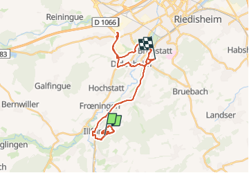
24 05 07 Illfurth les Orchidées

jmbilger
User

Length
28 km

Max alt
394 m

Uphill gradient
397 m
Km-Effort
33 km

Min alt
236 m

Downhill gradient
419 m
Boucle
No
Creation date :
2024-05-07 12:23:15.0
Updated on :
2024-05-08 03:06:37.444
2h36
Difficulty : Unknown

FREE GPS app for hiking
 SityTrail
IGN / Geographical institutes
SityTrail Plus
The world is yours!
About
Trail Walking of 28 km to be discovered at Grand Est, Haut-Rhin, Illfurth. This trail is proposed by jmbilger.
Positioning
Country:
France
Region :
Grand Est
Department/Province :
Haut-Rhin
Municipality :
Illfurth
Location:
Unknown
Start:(Dec)
Start:(UTM)
370569 ; 5281217 (32T) N.
Comments