


trace noir 2024

Jack29
User
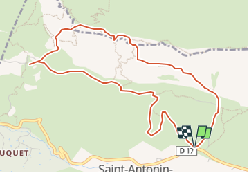

Length
5.8 km

Max alt
909 m

Uphill gradient
602 m
Km-Effort
13.9 km

Min alt
439 m

Downhill gradient
603 m
Boucle
Yes
Creation date :
2024-05-08 08:04:44.424
Updated on :
2024-05-08 08:05:42.194
3h09
Difficulty : Very difficult

FREE GPS app for hiking
 SityTrail
IGN / Geographical institutes
SityTrail Plus
The world is yours!
About
Trail Walking of 5.8 km to be discovered at Provence-Alpes-Côte d'Azur, Bouches-du-Rhône, Saint-Antonin-sur-Bayon. This trail is proposed by Jack29.
Positioning
Country:
France
Region :
Provence-Alpes-Côte d'Azur
Department/Province :
Bouches-du-Rhône
Municipality :
Saint-Antonin-sur-Bayon
Location:
Unknown
Start:(Dec)
Start:(UTM)
709312 ; 4821949 (31T) N.
Comments