


Mont Charvin

frizou83
User

Length
6.8 km

Max alt
2197 m

Uphill gradient
601 m
Km-Effort
14.8 km

Min alt
1603 m

Downhill gradient
599 m
Boucle
Yes
Creation date :
2024-05-10 16:05:39.528
Updated on :
2024-05-10 16:10:34.438
3h21
Difficulty : Difficult

FREE GPS app for hiking
 SityTrail
IGN / Geographical institutes
SityTrail Plus
The world is yours!
About
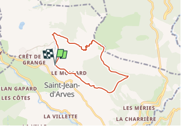
Trail Walking of 6.8 km to be discovered at Auvergne-Rhône-Alpes, Savoy, Saint-Jean-d'Arves. This trail is proposed by frizou83.
Positioning
Country:
France
Region :
Auvergne-Rhône-Alpes
Department/Province :
Savoy
Municipality :
Saint-Jean-d'Arves
Location:
Unknown
Start:(Dec)
Start:(UTM)
285702 ; 5010118 (32T) N.
Comments