


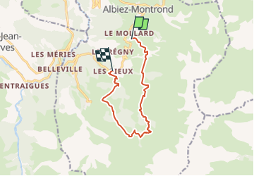
Circuit des Prés Naret

frizou83
User

Length
10 km

Max alt
1955 m

Uphill gradient
484 m
Km-Effort
17 km

Min alt
1444 m

Downhill gradient
653 m
Boucle
No
Creation date :
2024-05-10 16:21:22.145
Updated on :
2024-05-10 16:21:43.249
3h52
Difficulty : Difficult

FREE GPS app for hiking
 SityTrail
IGN / Geographical institutes
SityTrail Plus
The world is yours!
About
Trail Walking of 10 km to be discovered at Auvergne-Rhône-Alpes, Savoy, Albiez-Montrond. This trail is proposed by frizou83.
Positioning
Country:
France
Region :
Auvergne-Rhône-Alpes
Department/Province :
Savoy
Municipality :
Albiez-Montrond
Location:
Unknown
Start:(Dec)
Start:(UTM)
290924 ; 5009395 (32T) N.
Comments