


rando VTT du 14/05

dudu79
User
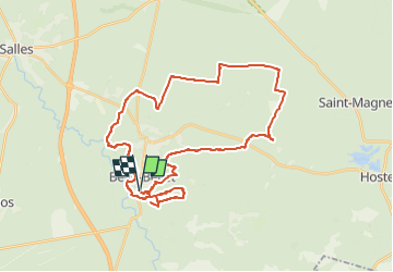

Length
40 km

Max alt
74 m

Uphill gradient
354 m
Km-Effort
45 km

Min alt
17 m

Downhill gradient
354 m
Boucle
Yes
Creation date :
2024-05-13 13:56:06.391
Updated on :
2024-05-13 13:56:08.719
3h05
Difficulty : Easy

FREE GPS app for hiking
 SityTrail
IGN / Geographical institutes
SityTrail Plus
The world is yours!
About
Trail Mountain bike of 40 km to be discovered at New Aquitaine, Gironde, Belin-Béliet. This trail is proposed by dudu79.
Positioning
Country:
France
Region :
New Aquitaine
Department/Province :
Gironde
Municipality :
Belin-Béliet
Location:
Unknown
Start:(Dec)
Start:(UTM)
675626 ; 4928321 (30T) N.
Comments