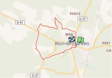
tuilerie, le mont, brouchon, fontaine St Jean - 7.1

les randonneurs rionnais
Pignada nous voilà

Length
7.1 km

Max alt
85 m

Uphill gradient
70 m
Km-Effort
8 km

Min alt
62 m

Downhill gradient
69 m
Boucle
Yes
Creation date :
2024-05-14 14:28:22.798
Updated on :
2024-05-14 14:55:03.404
1h49
Difficulty : Medium

FREE GPS app for hiking
 SityTrail
IGN / Geographical institutes
SityTrail Plus
The world is yours!
About
Trail Walking of 7.1 km to be discovered at New Aquitaine, Landes, Rion-des-Landes. This trail is proposed by les randonneurs rionnais.
Positioning
Country:
France
Region :
New Aquitaine
Department/Province :
Landes
Municipality :
Rion-des-Landes
Location:
Rion-des-Landes
Start:(Dec)
Start:(UTM)
666936 ; 4866618 (30T) N.
Comments