


Randonnée Pentecôte 2024

helmut68
User

Length
14.8 km

Max alt
534 m

Uphill gradient
266 m
Km-Effort
18.3 km

Min alt
353 m

Downhill gradient
266 m
Boucle
Yes
Creation date :
2024-05-19 09:03:49.805
Updated on :
2024-05-19 14:36:09.998
4h00
Difficulty : Medium

FREE GPS app for hiking
 SityTrail
IGN / Geographical institutes
SityTrail Plus
The world is yours!
About
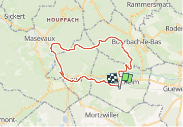
Trail Walking of 14.8 km to be discovered at Grand Est, Haut-Rhin, Sentheim. This trail is proposed by helmut68.
Description
Au départ de Sentheim direction col du Schirm ( Bourbach le Haut) .
Photos


Positioning
Country:
France
Region :
Grand Est
Department/Province :
Haut-Rhin
Municipality :
Sentheim
Location:
Unknown
Start:(Dec)
Start:(UTM)
353891 ; 5290545 (32T) N.
Comments